


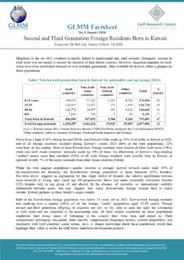


Bahrain: Population by governorate, nationality and sex (2010)


| Bahraini | Non-Bahraini | Total | |||||||
| Governorate | males | females | total | males | females | total | males | females | total |
| Capital | 34,147 | 33,442 | 67,589 | 190,884 | 71,037 | 261,921 | 225,031 | 104,479 | 329,510 |
| Muharraq | 51,706 | 50,538 | 102,244 | 57,148 | 29,722 | 86,870 | 108,854 | 80,260 | 189,114 |
| Northern | 97,833 | 96,229 | 194,062 | 52,701 | 30,186 | 82,887 | 150,534 | 126,415 | 276,949 |
| Central | 86,368 | 85,205 | 171,573 | 118,717 | 36,015 | 154,732 | 205,085 | 121,220 | 326,305 |
| Southern | 17,185 | 15,746 | 32,931 | 52,323 | 16,202 | 68,525 | 69,508 | 31,948 | 101,456 |
| Not Stated | 0 | 0 | 0 | 9,402 | 1,835 | 11,237 | 9,402 | 1,835 | 11,237 |
| Total | 287,239 | 281,160 | 568,399 | 481,175 | 184,997 | 666,172 | 768,414 | 466,157 | 1,234,571 |
Source: Central Informatics Organisation (CIO) – Bahrain
ANNEXED NOTE
1. Technical Notes and Definitions
The table provides data of Bahrain’s resident population based on the census of 2010, based on their place of residence by governorate, nationality and sex for the census year of 2010
Reference period for Census 2010 is April 27th, 2010 .
Implementation method: the Censuses are carried out according to de jure methodology, i.e. counting persons using their usual place of residence irrespective of where are they at census times
Population of reference: Bahrainis present within Bahrain’s borders during time of reference
Nationality is the person’s passport country. A Non-Bahrainis is considered as such depending on the passport used to enter the country (or obtain the visa).
A Governorate refers to an administrative, regiona, non-central unit, with a separate legal entity and budgetary provisions. Bahrain has been divided into governorates based on Decree (16) of 1996. Each governorate is headed by a governor that manages it, assisted by an assistant governor, an administrative body and a select number of individuals with a council.
2. Institution which provides data
Central Informatics Organization, known prior to 2001 as the “Central Statistics Organisation” under the Ministry of Cabinet Affairs
3. Data availability
This data is available on the Central Informatics Organisation (CIO) website. For the Arabic version: (http://www.cio.gov.bh/cio_ara/default.aspx). For the English version: (http://www.cio.gov.bh/CIO_ENG/Default.aspx)
Data for this census 2010 information can be found in a table in PDF format: (http://www.cio.gov.bh/cio_ara/English/Publications/Census/Population/2.pdf)
Data for this census 2010 information can also be found in the report titled “Census Summary Result 2010: Population, Housing, Buildings, Establishment and Agricultural Census released by the CIO”
General tables for the 2010 census data can be found in PDF format: (http://www.cio.gov.bh/CIO_ENG/SubDetailed.aspx?subcatid=256)
Information on the Bahraini governorates can be access through the Survey Land and Registration Bureau (SLRB): (http://www.slrb.gov.bh/Commerce/Products/152-area-of-kingdom-of-bahrain-by-governorates.aspx)
The map and list of towns and villages that fall under the Muharraq Governorate: (http://www.cio.gov.bh/CIO_ENG/English/Publications/Maps/Maps%20by%20Governorate/3_2008_Muharraq.pdf)
The map and list of towns and villages that fall under the Capital Governorate: (http://www.cio.gov.bh/CIO_ENG/English/Publications/Maps/Maps%20by%20Governorate/1_2008_Capital.pdf)
The map and list of towns and villages that fall under the Northern Governorate: (http://www.cio.gov.bh/CIO_ENG/English/Publications/Maps/Maps%20by%20Governorate/4_2008_North.pdf)
The map and list of towns and villages that fall under the Central Governorate: (http://www.cio.gov.bh/CIO_ENG/English/Publications/Maps/Maps%20by%20Governorate/2_2008_Central.pdf)
The map and list of towns and villages that fall under the Southern Governorate: (http://www.cio.gov.bh/CIO_ENG/English/Publications/Maps/Maps%20by%20Governorate/5_2008_South.pdf)
The maps are part of a list of publications released by the CIO on their website: (http://www.cio.gov.bh/CIO_ENG/SubDetailed.aspx?subcatid=89)
The definitions for the 2010′ census can be found in Arabic: (http://www.census2010.gov.bh/results.php)
Data of access: June 2014
Similar Posts:
- Bahrain: Population by nationality (Bahraini/ non-Bahraini), sex and age groups (2010)
- Bahrain: Population by nationality (Bahraini/ non-Bahraini), sex and age groups (2001)
- Bahrain: Population by nationality (Bahraini/ non-Bahraini), sex and age groups (1991)
- Oman: Population by nationality (Omani/ non-Omani), sex and administrative region (governorate) of residence (2010)
- Oman: Population by nationality (Omani/ non-Omani) and governorate (administrative region) of residence (2003).